
Hills and mountains to visit
Surrounding hills perfect for hiking
This is hills around city of Kotor. You can reach very fast by walk to the start point and immediately start with hike.
If you are into hiking, mountain biking, or extreme canyon adventures, mountain Vrmac, that is overlooking Tivat offers its slopes and a canyon to be conquered. Vrmac is a mountain in south-western Montenegro, overlooking the coastal town of Tivat and a peninsula dividing Tivat Bay from Kotor Bay. It is an extension of Mount Lovćen, and its highest peak is Sveti Ilija (Saint Elijah), which is 785 meters high. It is located north of town of Tivat, and encloses town of Kotor from the south. It is also the site of the Austro-Hungarian Fort Vrmac, built in 1860. Vrmac Tunnel, which connects Kotor with the Adriatic Highway, goes through the mountain. Vrmac is a popular destination for hiking, orienteering and mountain biking.
49 lokalkjente anbefaler
Vrmac
Jadranska magistralaIf you are into hiking, mountain biking, or extreme canyon adventures, mountain Vrmac, that is overlooking Tivat offers its slopes and a canyon to be conquered. Vrmac is a mountain in south-western Montenegro, overlooking the coastal town of Tivat and a peninsula dividing Tivat Bay from Kotor Bay. It is an extension of Mount Lovćen, and its highest peak is Sveti Ilija (Saint Elijah), which is 785 meters high. It is located north of town of Tivat, and encloses town of Kotor from the south. It is also the site of the Austro-Hungarian Fort Vrmac, built in 1860. Vrmac Tunnel, which connects Kotor with the Adriatic Highway, goes through the mountain. Vrmac is a popular destination for hiking, orienteering and mountain biking.
Pestingrad peak is located above Kotor at 1009 m. A beautiful panoramic view from this peak leaves no one indifferent. Once you reach the peak, you can enjoy in the mesmerizing panorama and tranquility while being refreshed by the breeze that is almost constantly present here. From the peak, one can see Kotor, Tivat and Luštica bays, the Tivat Airport, Vrmac Mountain, the city of Kotor, Perast, the two peaks of Lovćen – Jezerski Peak and Štirovnik, Mountain Orjen, etc. Pestingrad can be reached from several directions by marked trails. From the direction of Cetinje, we reach Pestingrad through Njeguši and Krstac. From Krstac, Pestingrad is about 2 km away. It is also possible to reach the peak along the marked trails from Kotor and this way the altitude difference is about 1000 m.
Kotor-Krstac-Pestingrad-Velji Zalazi-Dobrota-Kotor is a 21.6 kilometer moderately trafficked loop trail located near Kotor, Cetinje, Montenegro that offers scenic views and is rated as difficult. The trail offers a number of activity options and is best used from May until October.
From Krstac, there is a marked trail leading through lush nature to Pestingrad. After we reached the peak and spend some time enjoying the view, we went back the same way to Krstac. Then, in the opposite direction we headed towards Kotor, firstly along the tarred road and then again through nature, narrow wild paths and forest.
As we have entered the forest, we enjoyed being in the shade and only sometimes we could see bluish sea that looms across the dense treetops. From here the trail goes only downhill, all the way to the city of Kotor.
At the exit from the forest, the path widens and it becomes rocky and a bit slippery. It is a zigzag path with a beautiful view of Kotor Bay. Already tired we were trying to shorten our way by using as many shortcuts as possible.
Pestin Grad
Pestingrad peak is located above Kotor at 1009 m. A beautiful panoramic view from this peak leaves no one indifferent. Once you reach the peak, you can enjoy in the mesmerizing panorama and tranquility while being refreshed by the breeze that is almost constantly present here. From the peak, one can see Kotor, Tivat and Luštica bays, the Tivat Airport, Vrmac Mountain, the city of Kotor, Perast, the two peaks of Lovćen – Jezerski Peak and Štirovnik, Mountain Orjen, etc. Pestingrad can be reached from several directions by marked trails. From the direction of Cetinje, we reach Pestingrad through Njeguši and Krstac. From Krstac, Pestingrad is about 2 km away. It is also possible to reach the peak along the marked trails from Kotor and this way the altitude difference is about 1000 m.
Kotor-Krstac-Pestingrad-Velji Zalazi-Dobrota-Kotor is a 21.6 kilometer moderately trafficked loop trail located near Kotor, Cetinje, Montenegro that offers scenic views and is rated as difficult. The trail offers a number of activity options and is best used from May until October.
From Krstac, there is a marked trail leading through lush nature to Pestingrad. After we reached the peak and spend some time enjoying the view, we went back the same way to Krstac. Then, in the opposite direction we headed towards Kotor, firstly along the tarred road and then again through nature, narrow wild paths and forest.
As we have entered the forest, we enjoyed being in the shade and only sometimes we could see bluish sea that looms across the dense treetops. From here the trail goes only downhill, all the way to the city of Kotor.
At the exit from the forest, the path widens and it becomes rocky and a bit slippery. It is a zigzag path with a beautiful view of Kotor Bay. Already tired we were trying to shorten our way by using as many shortcuts as possible.
Mountain
The nearest mountain
Mount Lovćen as the Heart of the Country
The greatest hero of the Montenegrin people, Petar Petrovic Njegoš, lived in the Cetinje area (1813-1851). Today, he is celebrated as statesman, bishop, and the conscience of the people. He not only negotiated to keep most of Montenegro from succumbing to Turkish attacks, he also wrote the national masterpieces of poetry and literature.
During his lifetime, Njegoš picked Mount Lovćen as the place where he wanted to be buried. It took a while for his wishes to be granted due to historical events after his death, but in 1925 his remains were moved to the mountain. During World War II, the Italian army tried to blast his tomb with artillery, but never managed a hit. Decades later, the world’s tallest mausoleum (1660 meters above sea level) was finished in 1974 to honour Njegoš.
The sculptor tasked with designing the mausoleum, Ivan Mestrovic, sought to design the structure to honour the man and his main themes of “justice, freedom, and the dignity of Man and nations.” Upon submitting his design, Mestrovic refused compensation “except for a piece of cheese and the shoulder of a ram.” Today, Njegoš is still revered by much of the local population.
143 lokalkjente anbefaler
Lovćen
Mount Lovćen as the Heart of the Country
The greatest hero of the Montenegrin people, Petar Petrovic Njegoš, lived in the Cetinje area (1813-1851). Today, he is celebrated as statesman, bishop, and the conscience of the people. He not only negotiated to keep most of Montenegro from succumbing to Turkish attacks, he also wrote the national masterpieces of poetry and literature.
During his lifetime, Njegoš picked Mount Lovćen as the place where he wanted to be buried. It took a while for his wishes to be granted due to historical events after his death, but in 1925 his remains were moved to the mountain. During World War II, the Italian army tried to blast his tomb with artillery, but never managed a hit. Decades later, the world’s tallest mausoleum (1660 meters above sea level) was finished in 1974 to honour Njegoš.
The sculptor tasked with designing the mausoleum, Ivan Mestrovic, sought to design the structure to honour the man and his main themes of “justice, freedom, and the dignity of Man and nations.” Upon submitting his design, Mestrovic refused compensation “except for a piece of cheese and the shoulder of a ram.” Today, Njegoš is still revered by much of the local population.
Lovcen National Park is located in mountain Lovcen which is a part of the Dinaric Alps, in the southeast of Montenegro, between the Skadar Basin, the Bay of Kotor, and the Budva Riviera. It includes the area of 6,220 hectares, in the central and highest part of the mountain which represents a symbol of freedom and a “holy altar” to all of the Montenegrins.
Lovćen was declared a National Park in 1952. with the significant cultural and historical value among the locals. The famous serpentines represent a kind of architectural relic which is, besides the Mausoleum, one of the most visited places in the country.
Located at the intersection of two climate zones, Mediterranean and Continental, Lovcen National Park is inhabited with numerous endemic animal and plant species. The interesting fact is that one-third of the existing diverse Montenegrin flora grows here.
220 lokalkjente anbefaler
Lovćen nasjonalpark
Lovcen National Park is located in mountain Lovcen which is a part of the Dinaric Alps, in the southeast of Montenegro, between the Skadar Basin, the Bay of Kotor, and the Budva Riviera. It includes the area of 6,220 hectares, in the central and highest part of the mountain which represents a symbol of freedom and a “holy altar” to all of the Montenegrins.
Lovćen was declared a National Park in 1952. with the significant cultural and historical value among the locals. The famous serpentines represent a kind of architectural relic which is, besides the Mausoleum, one of the most visited places in the country.
Located at the intersection of two climate zones, Mediterranean and Continental, Lovcen National Park is inhabited with numerous endemic animal and plant species. The interesting fact is that one-third of the existing diverse Montenegrin flora grows here.
Durmitor is a massif located in northwestern Montenegro. It is part of the Dinaric Alps. Its highest peak, Bobotov Kuk, reaches a height of 2,523 meters (8,278 ft).
The massif is limited by the Tara River Canyon on the north, the Piva River Canyon on the west, and by the Komarnica River Canyon on the south. To the east, the Durmitor opens to a 1,500 m (4,921 ft) high plateau, called Jezerska površ (Plateau of Lakes). The Sinjavina mountain is located to the east of the Jezerska površ plateau. The Durmitor is for the most part located in the Žabljak municipality.
The massif gives its name to the national park that comprises it. Durmitor National Park was founded in 1952, and designated as a World Heritage Site in 1980.
131 lokalkjente anbefaler
Durmitor
Durmitor is a massif located in northwestern Montenegro. It is part of the Dinaric Alps. Its highest peak, Bobotov Kuk, reaches a height of 2,523 meters (8,278 ft).
The massif is limited by the Tara River Canyon on the north, the Piva River Canyon on the west, and by the Komarnica River Canyon on the south. To the east, the Durmitor opens to a 1,500 m (4,921 ft) high plateau, called Jezerska površ (Plateau of Lakes). The Sinjavina mountain is located to the east of the Jezerska površ plateau. The Durmitor is for the most part located in the Žabljak municipality.
The massif gives its name to the national park that comprises it. Durmitor National Park was founded in 1952, and designated as a World Heritage Site in 1980.
Bjelasica is a mountain in Montenegro. It is located in the heart of Montenegro or in the central-continental part. It evenly branches in four directions, and actually has a circular shape. It’s length and width is 30km and its area is around 630-km ². The boundaries are two major rivers, the Lim River and the Tara River and the Ljuboviđa and the Lepenica River from the north. It belongs to the municipalities of Kolasin, Mojkovać, Bijelo Polje, Bar and Andrijevica.
The mountain of Bjelasica is characterized by three important characteristics and comparative advantages: very easy mobility and accessibility to the highest mountain peaks, the great wealth of forests and abundance of running water. The mountain has a very good potential for the ski slopes. Unlike other mountains in the region, Bjelasica is of volcanic origin. Hence, green summer and winter white. While the water of Durmitor or Lovćen fail, everything stays here on the surface, flows into numerous streams and rivers, of which perhaps the most important and most beautiful is the Biograd River, which flows into the pearl of the mountain called the Biograd Lake.
The highest peak is Crna Glava of 2,139 meters high, then Crni vrh, Zekova glava and the peak of Ključ. Bjelasica leans equally on the picturesque mountain chains of Komovi on the southern slopes of the mountain.
9 lokalkjente anbefaler
Bjelasica
Bjelasica is a mountain in Montenegro. It is located in the heart of Montenegro or in the central-continental part. It evenly branches in four directions, and actually has a circular shape. It’s length and width is 30km and its area is around 630-km ². The boundaries are two major rivers, the Lim River and the Tara River and the Ljuboviđa and the Lepenica River from the north. It belongs to the municipalities of Kolasin, Mojkovać, Bijelo Polje, Bar and Andrijevica.
The mountain of Bjelasica is characterized by three important characteristics and comparative advantages: very easy mobility and accessibility to the highest mountain peaks, the great wealth of forests and abundance of running water. The mountain has a very good potential for the ski slopes. Unlike other mountains in the region, Bjelasica is of volcanic origin. Hence, green summer and winter white. While the water of Durmitor or Lovćen fail, everything stays here on the surface, flows into numerous streams and rivers, of which perhaps the most important and most beautiful is the Biograd River, which flows into the pearl of the mountain called the Biograd Lake.
The highest peak is Crna Glava of 2,139 meters high, then Crni vrh, Zekova glava and the peak of Ključ. Bjelasica leans equally on the picturesque mountain chains of Komovi on the southern slopes of the mountain.
Ski resort
The ski resort Kolašin 1450/Kolašin 1600 is located in Montenegro. For skiing and snowboarding, there are 45 km of slopes available. 7 lifts transport the guests. The winter sports area is situated between the elevations of 1,420 and 2,035 m.
From Kotor to Kolasin you need at least 2,5 hours with a car.
9 lokalkjente anbefaler
Ski Kolasin 1600
The ski resort Kolašin 1450/Kolašin 1600 is located in Montenegro. For skiing and snowboarding, there are 45 km of slopes available. 7 lifts transport the guests. The winter sports area is situated between the elevations of 1,420 and 2,035 m.
From Kotor to Kolasin you need at least 2,5 hours with a car.
13 lokalkjente anbefaler
Kolašin 1450
The ski resort Kolašin 1450/Kolašin 1600 is located in Montenegro. For skiing and snowboarding, there are 45 km of slopes available. 7 lifts transport the guests. The winter sports area is situated between the elevations of 1,420 and 2,035 m.
From Kotor to Kolasin you need at least 2,5 hours with a car.
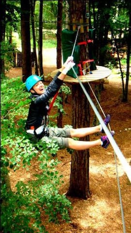
Adventure Park Lovcen
Adventure Park Lovcen is at Ivanova Korita in Lovcen National Park. To get there you’ll want head up there either via the serpentine road from Kotor or via Cetinje. Ivanova Korita is the gateway to Lovcen National Park. You can park here and explore the area from here – do the Adventure Park, hire bikes, eat at the restaurants or take a picnic! There’s a large grassed area that’s perfect for ball games and you’ll find picnic tables under shady trees. The park is always open during the opening times above and you can just arrive, no booking required.
Adventure Park Lovcen is series of ropes trails set up in the trees in Lovcen National Park. The national park is a fantastic area to visit during your stay in Montenegro – it’s close to the coast, the scenery on the way up from Kotor is stunning and there’s plenty to see and do up there. Have a look at our Lovcen National Park page here.
The Adventure Park has a series of ropes trails for you to navigate, all varying in difficulty. The great thing is there are trails here for everyone over the age of 5, so it’s a great family activity too. When you enter the park, you have can work your way around the courses and choose only those you feel comfortable with.
Each trail has 15 obstacles within in for you to complete with your group. There are trained instructors on site who’ll show you how to play the obstacles and complete the courses.
11 lokalkjente anbefaler
Adventures park Lovćen
Adventure Park Lovcen is series of ropes trails set up in the trees in Lovcen National Park. The national park is a fantastic area to visit during your stay in Montenegro – it’s close to the coast, the scenery on the way up from Kotor is stunning and there’s plenty to see and do up there. Have a look at our Lovcen National Park page here.
The Adventure Park has a series of ropes trails for you to navigate, all varying in difficulty. The great thing is there are trails here for everyone over the age of 5, so it’s a great family activity too. When you enter the park, you have can work your way around the courses and choose only those you feel comfortable with.
Each trail has 15 obstacles within in for you to complete with your group. There are trained instructors on site who’ll show you how to play the obstacles and complete the courses.